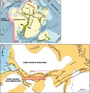
When the African-South American separation modified continental erosion

Land masses outside mountain ranges account for more than 60% of the world’s landmass. Despite their low relief and erosion, they make a significant contribution to the flow of sediments exported to the ocean. However, unlike mountain ranges, their export capacity has rarely been studied and has never been fully quantified. This constitutes a major bias in global erosion budgets, which are fundamental to understanding the links between climate, landforms and biogeochemical cycles on a global scale.

a) Map of the African and South American rift systems (in green) around 120 Ma during the break-up of the Gondwana continent. b) Palaeogeographic map of the study area (fixed Africa) during the Aptian (120-115 Ma) showing the main deformation structures and sedimentation domains (orange: continental; yellow: deltaic; light blue: shallow marine; dark blue: deep marine). The current shoreline is shown in blue.

Read more on the INSU website.

GET contact: Delphine Rouby

Sources :

Rouby et al., Source-To-Sink Sedimentary Budget of the African Equatorial Atlantic Rifted Margin, Geochemistry, Geophysics, Geosystems, 2023

More news

Unprecedented mineral and organic compounds discovered in Mars’ Jezero Crater

The Perseverance rover has uncovered sedimentary rocks containing minerals and organic matter organized into structures never before seen on Mars, opening up new perspectives on the Red Planet’s past habitability. […]

Climate warning for archaeological sites

From the Chauvet cave to the Ile d’Yeu, prehistoric sites are under close surveillance. The hope: to understand how climate change threatens them. And prevent the disappearance of cave paintings. […]

The origins of continents: continental crust shaped by water

ow did continents appear on Earth? This question, crucial to understanding the emergence of civilizations and life itself, remains one of the great mysteries of the early stages of planetary […]

Search