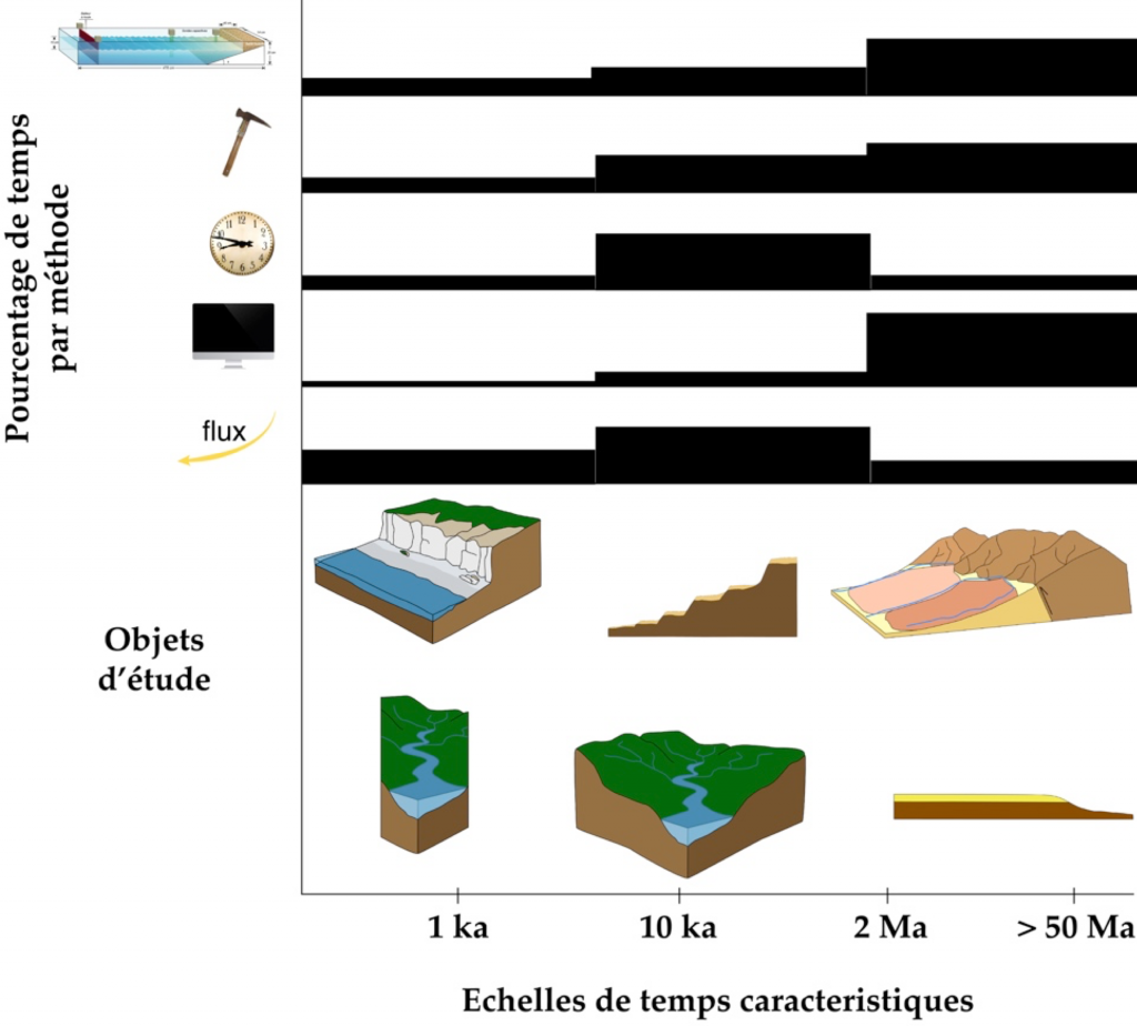
The strengths of our geomorphology group are the quantification of denudation processes (erosion and weathering), from sediment production by landslides to sediment transfer to the oceans, from outcrop to continental surfaces via rocky coasts and over a wide range of timescales (1-107 years) development of unique “long-term” numerical and experimental models, synthesis of geomorphological (source) and sedimentological (sink) data, and development of new applications of cosmogenic isotopes and OSL (Optically Stimulated Luminescence) for the quantification of medium- and long-term river dynamics. The effect of climatic variations on landforms and flows remains a guiding thread for our projects. Vegetation is not at the heart of our projects, but we are thinking about including it in our analyses and modeling.
Participants: S. Carretier (coord.), S. Bonnet, G. Caravaca, D. Chardon, F. Christophoul, O. Marc, V. Regard, D. Rouby, Y. Denèle, Y. Goddéris.
Axis 1: Erosion and alteration fluxes
Sedimentary archives constitute the only window to ancient sedimentary environments and fluxes, however the signals carried by the proxies contained in the sediments (mineralogy, granulometry, elemental and isotopic chemistry, cosmogenic isotopes, alteration indices, biota) remain complex to interpret. In particular, the relationship between climate variations (T~10ka-10Ma) and these proxies is not always clear. To understand how erosion and weathering fluxes vary, we reconstruct landforms and weathering profiles in Africa over the Cenozoic to move towards a synthesis at continental and inter-continental scales, notably by comparing different climate zones (JEAI FasoLith, FasoReg and COLORS projects). At a more process-like scale, we quantify denudation rates of experimental basins of the OZCAR SNO network using 10Be and compare them to measured dissolved fluxes. In addition, we use the CIDRE (Carretier et al.) and FASTCAPE (Braun et al.) codes to model the evolution of solid, dissolved fluxes, and the mineralogy and grain size of sediments exiting catchments subjected to climatic variations at different stages of topographic evolution, in order to better interpret stratigraphic proxies. In particular, we address the effect of temporary sediment storage, weathering and recycling on the stratigraphic record. We couple CIDRE with WHITCH (Goddéris et al.) to better describe soil weathering. These approaches are strongly coupled with the projects of the LOA paleoenvironment group. Furthermore, and this is one of our originalities, we are pursuing our efforts to better understand the geomorphological control of the concentration of metals associated with weathering processes (Al, Fe, Cu), in West Africa and in Chile and Peru (FasoReg project and LMI COPEDIM).
Axis 2: Landslides
With the recent recruitment of Odin Marc (CNRS), our activities on landslides are increasing. The production of sediments in the “source” part of watersheds completes our source-to-sink approach, and will allow us to strengthen the link with other groups within GET, especially on the environmental risk aspect. We are developing an approach to landslides based on the constitution of large catalogs of landslides, correlated with the triggering factors: earthquakes and rainfall events. This analysis uses satellite, optical and radar data and a multidisciplinary expertise that creates links with other teams of GET and OMP. We also address gravity sediment production through numerical modeling, analysis of high-resolution DTMs, and characterization of grain sizes produced in the field. Our goal is both to improve landslide prediction and to understand the long-term (> 1ka) impact of landslides on landscapes and sediment fluxes.
Axis 3: Fluvial dynamics
We have been pioneers in showing that geomorphic couplings at the front of a chain control landscape dynamics, but many questions remain. To document these dynamics at the front of the Pyrenees, we synthesize sedimentological data from the Pyrenean piedmont in the post-orogenic phase in the form of paleogeographic maps and volume balances of deposited sediments. Based on this synthesis, and on new burial (cosmogenic) dating, we try to understand the age and significance of the relict surfaces preserved in the chain. We are also implementing a campaign of measurements of different cosmogenic isotopes to date the burial of the sediments of the piedmont, to specify the timing of the incision, and to complete the mapping of the millennial erosion rates of the chain.
To understand how and how fast a drainage network grows and the reorganizations of hydrographic networks that accompany this growth phase, we conduct model watershed experiments using a new experimental device developed at GET (FogBox). This device is also used to study the formation of river terraces, both autocyclic and allocyclic (climate, uplift), by including in an original way and for the first time (except for some pioneering experiments carried out by Stanley Schumm’s team in the 70’s), the “natural” production of sediment by erosion in the headwaters of the watershed rather than imposing an input flow as in all channel experiments. We are convinced that considering the formation of terraces in the context of the global dynamics of the watershed is absolutely essential to advance the understanding of these emblematic objects in Geomorphology. Our natural reference systems for these experiments are the rivers of the Pyrenean foothills (Aude, Garonne and Adour), of New Zealand (Rangitikei) and of the Andes (Chile), all sites where we are already carrying out terrace dating work using OSL and 10Be. The experimental models are of course compared to numerical models (CIDRE or EROS – Davy et al.).
Our work on fluvial dynamics also aims to better understand the link between fluvial morphology and long-term transport dynamics of grains in a river. In a very innovative way, we study the bleaching (resetting) of the luminescence signal (OSL) of particles transported in a river, in close collaboration with the Netherlands Center for Luminescence Datings and the University of Cologne. Our preliminary work shows that the longitudinal variations of this signal along a river depend on the transport processes and their efficiency. It is necessary to better constrain these relationships and we continue to work on the Rangitikei River sands (New Zealand), an approach that we couple with statistical transport models to relate bleaching to the distribution of grain transport distances over several thousand years. We are also trying to develop this approach in the ancient (on terrace sands), in order to provide new information on past transport processes. In parallel, we are pursuing similar efforts on pebbles, by measuring their 10Be concentration from a single lithological source (Andes, Cevennes, Africa), as we have recently done on a river in Chile.
Finally, we are actively working on an often neglected dimension of river dynamics: the widening of valleys by lateral erosion of rivers. This phenomenon is at the origin of the formation of river terraces, contributes to the formation of pediments, and is an integral part of the dynamics of adaptation of landforms and flows to climatic and tectonic changes over the long term. It is very difficult to address this phenomenon (which often remains absent from models) because it incorporates a large variability of erosive events, from the slow lateral migration of river channels that occasionally “touch” the valley edges, to catastrophic events such as those recently experienced by rivers in the Vésubie region. We are developing an innovative approach to quantify the average of these contributions using cosmogenic isotopes. We are therefore very hopeful that this new approach will remove the main lock to address this problem.
Axis 4: Rocky coasts
Our team is a leader in the study of rocky coasts (V. Regard is an Associate Editor at ESPL for this specialty). Our recent work has resulted in the most rigorous and complete published database of cliff recession rates. From this database and the resulting parametric model, we estimate for the first time the global erosion fluxes of rocky coasts. However, this database is still severely lacking in data, especially in the intertropical zone, where the climate could favor coastal erosion. We are therefore undertaking quantifications on several time scales by combining the use of cosmogenic isotopes, satellite images and Lidar. In particular, we study coastal erosion on volcanic islands, which offer a wide range of environmental conditions. In addition, we are developing numerical modeling of long-term erosion of coastal cliffs, which coupled with CIDRE, will allow to take into account the contribution of sediments by rivers and their transport by coastal currents to better understand their influence on the recession of cliffs, and the morphology of marine terraces in the context of uplift.